Real-time storm data, including that of Category 4 Hurricane Fiona, approaching eastern Canada, is being collected using instruments such as Saildrones.
Last fall, OAA oceanographer Greg Foltz closely monitored Hurricane Sam’s tracking and intensity, analyzing satellite images and data to estimate its trajectory over the next 12-24 hours.
He needed to position an uncrewed surface vehicle (USV) called a Saildrone in the hurricane’s path to collect real-time storm data. Contrary to pulling his equipment away from the storm’s path, Foltz wanted a direct hit by the Category 4 storm. He communicated with Saildrone’s “mission control” to adjust its path based on his analysis of the storm’s movements. Foltz recounted:
“I was constantly adjusting the location where we wanted the Saildrone to be in order to go through the strongest part of the storm. I directed in real-time where to take the Saildrone to get it in the best spot to go through the most powerful part of the hurricane, and that was exhilarating. I didn’t really sleep at all the night before as I was trying to get it into the right position.”
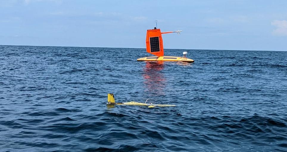
Matt Womble, Director of Ocean Data Programs for Saildrone, Inc., explains that the hurricane Saildrones are designed with a specialized “hurricane wing” that allows scientists to remotely control and steer the craft. Unlike other Saildrone products used for ocean mapping, data collection, and maritime awareness, the hurricane drones are equipped with a smaller, sturdier wing that enhances their endurance and ability to withstand harsh weather conditions during hurricane season.
While Hurricane Sam raged with its Category 4 winds and huge waves, the Saildrone faced the elements. The team monitored the live data and video feed to witness the hurricane’s power. After the storm weakened, they steered the drone towards Bermuda and retrieved it with minimal damage.
Expanding Hurricane Saildrone project this hurricane season
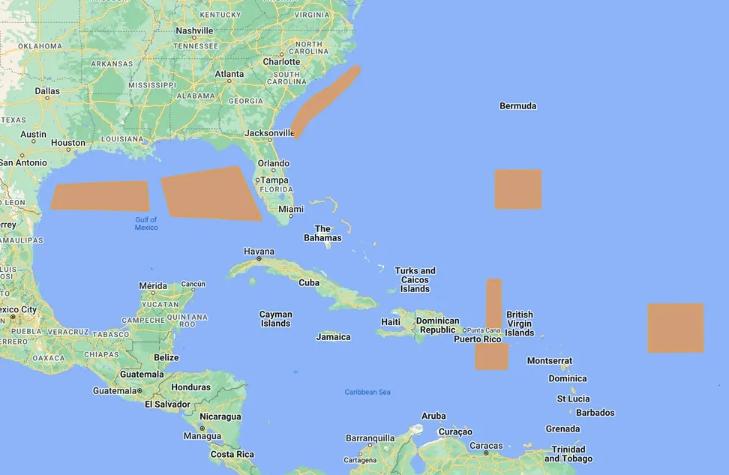
NOAA and Saildrone are increasing the scope of last year’s successful mission by deploying two more Saildrones, bringing the total to seven, this hurricane season. With two drones stationed in the Gulf of Mexico and five in the Atlantic and Caribbean, the researchers are deploying them in areas where they anticipate the likelihood of storm development. In the previous year, Saildrones collected valuable data on Hurricane Sam, in addition to four tropical storms, a few weaker tropical depressions and storms.
A major area of focus for scientists is the rapid intensification of hurricanes. When a hurricane rapidly intensifies, people can be caught off guard and unable to evacuate or prepare properly, which can result in deaths and extensive damage.
Through the transmission of real-time data to hurricane forecasters, the aim is to improve the accuracy of forecasts, as well as to enhance hurricane modeling and predictions.
According to Foltz, climate change is responsible for intensifying hurricanes, increasing the maximum potential intensity that a hurricane can achieve. He suggests that climate change raises the “speed limit” of a hurricane, indicating the maximum wind speed limit that a hurricane can reach. However, he also notes that this does not imply that all hurricanes will become stronger, but rather that the upper limit of a hurricane’s maximum intensity is increased under certain circumstances.
The Saildrones gather a variety of data such as air and water temperature, humidity, wind speed and direction, barometric pressure, salinity, wave height, and period. They also capture and transmit video footage. The researchers analyze this data to gain insights into a range of topics such as energy exchanges, momentum, and hurricane intensification.
“Going to sleep with a Category 1, but awakening to a Category 4”
Saildrones are part of a group of instruments used for studying strong ocean storms through “co-located measurements”. This approach involves collecting data from various locations to provide researchers with a comprehensive set of measurements to study hurricanes. Other instruments used for this purpose include underwater gliders, which can measure salinity and temperature at greater depths, ocean floats and drifters for data collection, small uncrewed aircraft systems (sUAS) for measurements several hundred feet above sea level, and dropsondes that are deployed from “Hurricane Hunter” aircraft.
According to Hugh Willoughby, a tropical meteorologist and professor at Florida International University, Saildrone’s data collection presents a fresh approach to an age-old problem. He believes that by using the data collected, researchers will be able to identify areas where their understanding of hurricanes is flawed, leading to more accurate models and forecasts that will ultimately save lives and prevent property damage.
The team, led by Foltz, is in the process of analyzing the data collected from the previous hurricane season, and is also currently gathering data for this year. In addition to sharing their findings through research papers, they are hopeful that the data can be used to create practical applications that can ultimately save lives.
Womble, from Saildrone, highlights the potential impact of their data on improving hurricane intensification forecasts. He recalls a statement made by a scientist during a kick-off event for the hurricane mission, which warned that people could go to bed expecting a Category 1 storm, only to wake up the next morning with a Category 4 hurricane approaching.
Womble emphasizes the importance of Saildrone’s data in improving hurricane intensity forecasts, noting the potential to avoid a scenario where people are caught off-guard by an unexpected Category 4 storm. He mentions the difficulties that arise when people have little time to make decisions for themselves and how the Saildrones could aid in providing better information to facilitate decision-making during such scenarios. Womble also expresses excitement about the potential impact of Saildrone’s data on improving forecasts and making decisions easier for people.